The Line That Divides the World
The Prime Meridian at the Royal Observatory Greenwich is the imaginary line that runs from the North Pole to the South Pole at exactly zero degrees longitude. Every other line of longitude on Earth is measured east or west from this point, making Greenwich the reference from which all positions on the globe are calculated.
Unlike the equator, which is determined by the Earth's rotation and sits at the widest point of the planet, the Prime Meridian is an entirely human choice. There is nothing in nature that dictates where zero degrees longitude should fall. For centuries, different countries used their own capital cities or observatories as the zero point, which created confusion for navigation and mapmaking.
Why Greenwich Was Chosen
By the late 19th century, the expansion of international shipping and the growth of railway networks made a single global standard essential. In 1884, delegates from 25 nations gathered at the International Meridian Conference in Washington DC to settle the question.
Greenwich was selected for several reasons. The Royal Observatory had been producing highly accurate astronomical observations since its founding in 1675. British naval charts, which were used by a large proportion of the world's shipping, already used Greenwich as their reference point. And the United States, which hosted the conference, had adopted Greenwich as the basis for its own time zones in 1883.
The vote was not unanimous. France abstained, preferring Paris as the zero point, and continued to use the Paris Meridian for several decades before eventually adopting Greenwich. But the practical dominance of British maritime charts made the outcome almost inevitable.
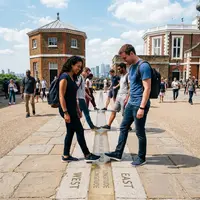
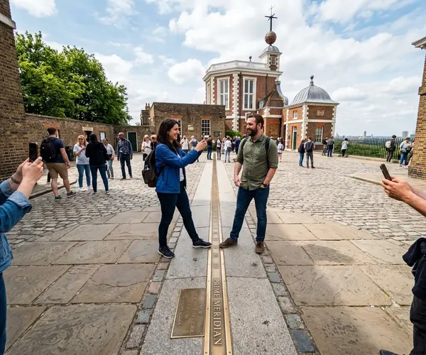
The Brass Line in the Courtyard
The physical marker of the Prime Meridian at Greenwich is a brass strip set into the ground of the Observatory courtyard. It runs north to south through the cobblestones, and visitors can stand with one foot in the Eastern Hemisphere and one in the Western Hemisphere.
This line has been marked in various ways over the years. The current brass strip replaced an earlier stone marker, and at night a powerful green laser beam is projected northward along the meridian from the Observatory roof, visible across London. The laser was installed in 1999 and has become a distinctive feature of the Greenwich skyline after dark.
A Modern Complication
GPS technology has introduced an interesting wrinkle. The GPS meridian, based on the World Geodetic System, actually falls approximately 102 metres east of the brass line at Greenwich. This discrepancy exists because the original meridian was established using astronomical observations that were affected by a slight local deflection of gravity caused by the mass of the nearby hills.
The brass line at the Observatory remains the historically and culturally recognised Prime Meridian, even though modern satellite navigation uses a slightly different reference. Both are valid measurements, they simply use different methods of determining where zero falls.
The Meridian Beyond Greenwich
The Prime Meridian does not only pass through Greenwich. Following the line northward, it crosses Essex and then the North Sea before reaching the coast of East Yorkshire. Heading south from Greenwich, it passes through France, Spain, Algeria, Mali, Burkina Faso, Togo, Ghana and Antarctica.
Several towns and cities along the line have erected their own markers. But Greenwich remains the definitive point, the place where the line was established and where millions of visitors come each year to stand on the boundary between East and West. The combination of scientific history, global significance and a simple brass strip in a courtyard makes it one of the most meaningful lines drawn anywhere on Earth.